Cessnock Black Creek Stage 1 Flood Risk Management Study and Plan
Consultation has concluded

Project update: Thank you for participating in our survey. Please note initial consultation has now concluded, and staff will update the project once a draft Stage 1 Floodplain Risk Management Study and Plan is available on open for community feedback.
About the Process for Managing Flood Risk
We have many areas across the Cessnock Local Government Area that are exposed to flood risk. We're committed to using the latest data and insights to inform our planning, resilience and responses to natural disasters. We understand our community is best placed to work together with us in improving our knowledge of flood impacts on the LGA.
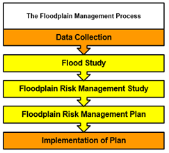
As part of this work, each catchment area in Cessnock will have a Flood Study then a Plan developed to reduce the impact of flooding. The final step for each catchment is a document called a Flood Risk Management Study and Plan (FRMSP).
The Study and Plan are developed following the NSW Government's guidance in the Flood Risk Management Manual 2023.(External link)
The FRMSP is developed in the following order:
- Flood Study – investigates how flood waters are likely to behave or move through the catchment.
- Floodplain Risk Management Study – This study builds on the flood study findings to look at how flooding will affect the community. It also considers different options to reduce flood risk.
- Floodplain Risk Management Plan – This plan includes the actions and guidelines to be implemented to manage flood risk in the catchment.
About the Cessnock Black Creek Stage 1 Flood Risk Plan Management Study and Plan
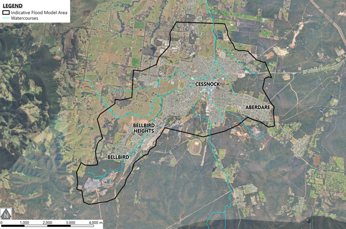
We are currently undertaking an updated Flood Risk Management Study and Plan (FRMSP) for the Black Creek Stage 1 catchment, which includes the township of Cessnock and its satellite suburbs of Bellbird and Aberdare.
A previous Flood Risk Management Study and Plan for the Black Creek Stage 1 catchment was completed in 2016. Since that time, a range of changes have occurred that require the study to be updated. These include the availability of new high-resolution LiDAR survey data captured in 2024, recent flood mitigation and drainage works within the floodplain (including the South Cessnock Flood Mitigation Scheme), and updates to industry best-practice flood modelling and assessment methods, including the application of Australian Rainfall and Runoff 2019 (ARR2019) and flood modelling tools such as WBNM and TUFLOW.
The purpose of this updated FRMS is to provide an improved understanding of flood behaviour across the Black Creek Stage 1 catchment which takes into account the changes described above. The updated understanding of flood behaviour will inform investigations into potential measures to reduce the impacts of flooding on life and property and will provide information to support land use planning and future development. In particular, the study will include a flood assessment for proposed development within the Cessnock Commercial Precinct.
At the completion of the study, the findings will be used to develop an updated Floodplain Risk Management Plan to guide Council and the community in managing flood risk in a coordinated, practical and sustainable way.
About the Floodplain Risk Management Program
The current study is being completed by Council with assistance from Worley Consulting as part of the NSW Government’s Floodplain Risk Management Program. This program supports local councils in making informed decisions about managing flood risks and provides essential information to the State Emergency Service (SES) for coordinating flood emergency responses. The program consists of five stages as shown in the flowchart on the right.
The program recognises that flood prone land is a valuable resource that should not be sterilised by unnecessarily precluding its development. At the same time, the program seeks to reduce the impact of flooding and flood liability on individual owners and occupiers of flood prone property.
The flood study will assess flood behaviour at Cessnock by providing information on flood depths, levels, velocities, hazards and extents for a range of flood magnitudes. This includes information for the ‘Probable Maximum Flood’, which is the largest flood which could conceivably occur.
The Flood Risk Management Study and Plan (FRMSP) uses the information established in the flood study to develop a strategy for Council and the local community to effectively manage and reduce flood risk. It helps provide relevant and latest information to help make decisions such as the following.
- Planning: Helps in making informed decisions for future developments and taking steps to reduce flood risks in existing areas.
- Policy Review: Assists in evaluating and updating local flood risk management policies and strategies.
- Risk Assessment: Aids in identifying and assessing mitigation measures to minimise social, environmental, and economic impacts of flooding.
Important Documents
Click on the links below to view the important documents that relate to this project
Project Area
The study area includes flooding associated with Black Creek and its major tributaries, including Kearsley Creek, Aberdare Creek, Bellbird Creek, Lavender Creek, Limestone Creek, as well as the network of constructed concrete drainage channels within the Cessnock urban area. Flooding along these watercourses, as well as stormwater runoff which exceed the capacity of local drainage systems, can lead to the inundation of surrounding streets, properties and public spaces.
Important Questions
- Why is the Black Creek Catchment Stage 1 Floodplain Risk Management Study and Plan being updated now?
- What are the next steps?
- Why are Flood Management Studies and Plans beneficial?
- Where can I find support during or following a flooding event?
How can you help us?
Community input is invaluable to this study. Your knowledge and experiences of flooding and drainage problems are an invaluable source of data and will help to define the nature and the extent of flooding. In order to verify predictions of peak flood extents and levels, we would like to know if you can identify any flood marks that you or others may have recorded during previous flood events. For example, you may remember floodwaters reaching a certain height on a landmark (such as a tree or building) or specific roads that were “cut off” by floodwaters.
Photographs are especially useful in validating the behaviour of a past flood event. Photos which clearly show flood levels or extents can help us verify the results of the flood modelling and identify where flooding and drainage problems have been experienced. Similarly, we would like to obtain any private rainfall recordings that you may have compiled during past events.
Right now, we are seeking first-hand information of any flooding or drainage problems that you have experienced to help us better understand the issues that are important to you. If you think you can help, we would appreciate you completing the Cessnock Black Creek Stage 1 Flood Risk Management Study survey at the bottom of this page.
This survey can also be completed as a physical copy which is available at the Cessnock City Council Administration Building. Please return the physical copy in-person, via email to stormwater@cessnock.nsw.gov.au or via post to Cessnock City Council, 62-78 Vincent St, Cessnock, New South Wales 2325. If you are unable to travel to our Administration Building, please contact us and we can mail a copy of the survey to you.
Would you like to know more or provide feedback?
You may:
- Ask the project team a question below
- Request a conversation with the team below
- Make a comment or submission below
- Phone: Council Customer Service on 02 4993 4100
- Email your submission or question to council@cessnock.nsw.gov.au
