Draft Cessnock LGA Wide Overland Flood Study
Share Draft Cessnock LGA Wide Overland Flood Study on Facebook Share Draft Cessnock LGA Wide Overland Flood Study on X (formerly Twitter) Share Draft Cessnock LGA Wide Overland Flood Study on Linkedin Email Draft Cessnock LGA Wide Overland Flood Study link

Project Overview

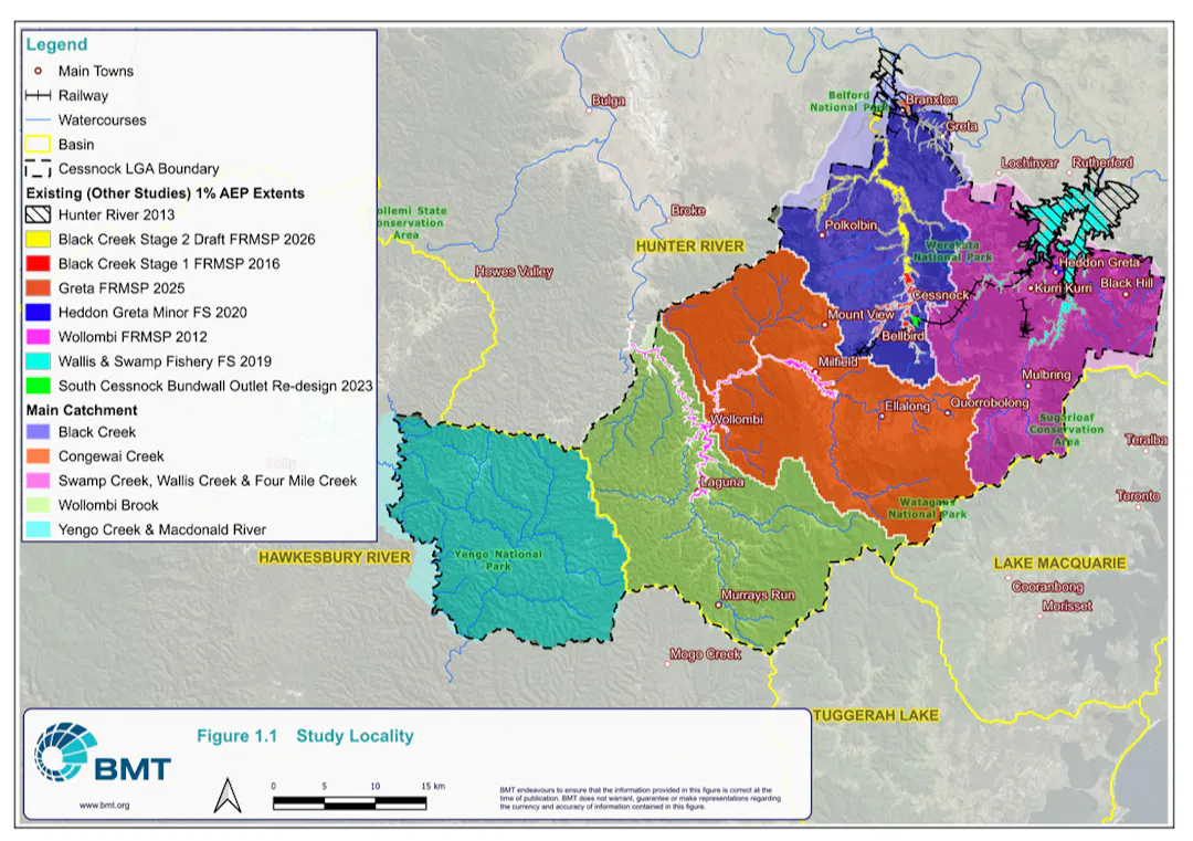
The Draft Cessnock LGA Wide Overland Flood Study maps flooding from overland flow and minor watercourses across the Cessnock Local Government Area. It has been prepared for Council by BMT Commercial Australia Pty Ltd. The study covers approximately 1,965 km² across five major catchments: Swamp Creek, Wallis Creek and Four Mile Creek; Black Creek; Congewai Creek; Wollombi Brook; and Yengo Creek and Macdonald River. Within these catchments it maps the flooding that occurs outside the areas covered by Council’s adopted creek and river flood studies.

Overland flow paths are natural low points that stay dry most of the time but carry water during large storms. Minor watercourses are small creeks and gullies that can overflow in heavy rain. Both can affect homes, businesses and roads, so they need to be understood when planning development and infrastructure.

A previous interim study was adopted in 2021. Since then, new high‑resolution LiDAR ground level data (captured in June 2024) and updated national guidance (Australian Rainfall and Runoff 2019) have allowed a more accurate study to be prepared.

The draft study uses TUFLOW computer flood models that apply rainfall across each catchment and track where the water flows. The models have been checked against the June 2007 and April 2015 floods. The study provides improved information on flood levels, depths, velocities, hazards and extents for a range of flood sizes. This will be used to update the Flood Planning Area, set planning levels, update section 10.7 certificates, assess major development proposals, support drainage planning and assist emergency response.

The draft study replaces the Cessnock City Wide Flood Study (2021). It does not replace the adopted creek and river studies listed above. Where those studies apply, their results continue to be used.


About the Process for Managing Flood Risk

We have many areas across the Cessnock Local Government Area that are exposed to flood risk. We are committed to using the latest data and insights to inform our planning, resilience and responses to natural disasters. We understand our community is best placed to work together with us in improving our knowledge of flood impacts on the LGA.

Council’s adopted flood studies cover the main creeks and rivers, such as Black Creek, Wallis and Swamp Creeks, Wollombi Brook and the Hunter River. This study is an LGA‑wide overland flood study. It fills the gaps between those studies by mapping flooding that occurs away from the main watercourses, where stormwater runoff flows overland through streets, properties and natural low points during large storms.

The study will be used to set development controls for flood‑affected land and to give property owners a clearer picture of their flood risk.


What is changing?

The main change is an updated Flood Planning Area (FPA). This area includes land affected by the 1% AEP flood plus a safety margin called freeboard. Land within the Flood Planning Area is subject to flood‑related development controls.

In the draft study, freeboard is 0.3 m for overland flow paths and 0.5 m for major flow paths and waterways. Council has been applying double freeboard to land mapped in the 2021 study because it was less accurate. The draft study is accurate enough for this to be removed through a separate amendment to the Development Control Plan.

Under the draft study:

  • 12,370 properties are in the current Flood Planning Area

  • 11,948 properties are in the proposed Flood Planning Area

  • 1,444 properties are no longer identified as flood affected

  • 1,022 properties are identified as flood affected for the first time

  • Overall, 422 fewer properties are affected

Changes come from better ground level data, a more detailed flood model and updated national rainfall guidance. Flood extents are larger in some areas because design rainfall must now be increased by 11-18% to reflect current climate conditions. Flood extents are smaller in others because the detailed model removes areas incorrectly picked up in the 2021 study.

This does not reflect a change in flood risk on the ground, it is simply a more accurate picture of the risk that already exists.


View the Plan

Click the Document to view:

  • Cessnock LGA Wide Overland Flood Study (Volume 1)
  • Cessnock LGA Wide Overland Flood Study (Volume 2) - This document is a list of mapping sets informing the Draft Flood Study that are available for viewing. Due to the large file sizes, we are unable to upload a digital copy of all maps that would be user friendly. Please email us at together@cessnock.nsw.gov.au and let us know which mapping set you would like to view. We will send you a link via email, zip file or post you a hardcopy of the maps requested.
  • Take a look at our Interactive Map to compare the relevant 2021 map compared to the proposed 2026 map. You may highlight a flooding experience to a location.

You can also view a hard copy of these documents at:

  • Cessnock Library - 65/67 Vincent St, Cessnock NSW 2325
  • Kurri Kurri Library - 253 Lang St, Kurri Kurri NSW 2327
  • Council Administration Building - 62-78 Vincent St, Cessnock NSW 2325
  • Hunter Valley Visitor Information Centre - 455 Wine Country Drive, Pokolbin NSW 2320

How to get involved -

Please continue further down this page to find the options to:

1. Complete an online submission/survey

2. Make a submission via email or post

3. Express your interest in a Community Information Session

4. Request a conversation with the project team

5. Ask a question of the project team


How to make a submission

You can make a submission using the online form located below or by clicking this link.

Should you intend to make a submission on the draft Plan in writing you may do so by Wednesday 18 November 2026. Please quote “Draft Cessnock LGA Wide Overland Flood Study" in the subject field. Submissions should be addressed to The General Manager and can be submitted via:

Alternatively, if you would like to speak with the project team or ask a question, you can submit a request or question below.

Project Overview

The Draft Cessnock LGA Wide Overland Flood Study maps flooding from overland flow and minor watercourses across the Cessnock Local Government Area. It has been prepared for Council by BMT Commercial Australia Pty Ltd. The study covers approximately 1,965 km² across five major catchments: Swamp Creek, Wallis Creek and Four Mile Creek; Black Creek; Congewai Creek; Wollombi Brook; and Yengo Creek and Macdonald River. Within these catchments it maps the flooding that occurs outside the areas covered by Council’s adopted creek and river flood studies.

Overland flow paths are natural low points that stay dry most of the time but carry water during large storms. Minor watercourses are small creeks and gullies that can overflow in heavy rain. Both can affect homes, businesses and roads, so they need to be understood when planning development and infrastructure.

A previous interim study was adopted in 2021. Since then, new high‑resolution LiDAR ground level data (captured in June 2024) and updated national guidance (Australian Rainfall and Runoff 2019) have allowed a more accurate study to be prepared.

The draft study uses TUFLOW computer flood models that apply rainfall across each catchment and track where the water flows. The models have been checked against the June 2007 and April 2015 floods. The study provides improved information on flood levels, depths, velocities, hazards and extents for a range of flood sizes. This will be used to update the Flood Planning Area, set planning levels, update section 10.7 certificates, assess major development proposals, support drainage planning and assist emergency response.

The draft study replaces the Cessnock City Wide Flood Study (2021). It does not replace the adopted creek and river studies listed above. Where those studies apply, their results continue to be used.


About the Process for Managing Flood Risk

We have many areas across the Cessnock Local Government Area that are exposed to flood risk. We are committed to using the latest data and insights to inform our planning, resilience and responses to natural disasters. We understand our community is best placed to work together with us in improving our knowledge of flood impacts on the LGA.

Council’s adopted flood studies cover the main creeks and rivers, such as Black Creek, Wallis and Swamp Creeks, Wollombi Brook and the Hunter River. This study is an LGA‑wide overland flood study. It fills the gaps between those studies by mapping flooding that occurs away from the main watercourses, where stormwater runoff flows overland through streets, properties and natural low points during large storms.

The study will be used to set development controls for flood‑affected land and to give property owners a clearer picture of their flood risk.


What is changing?

The main change is an updated Flood Planning Area (FPA). This area includes land affected by the 1% AEP flood plus a safety margin called freeboard. Land within the Flood Planning Area is subject to flood‑related development controls.

In the draft study, freeboard is 0.3 m for overland flow paths and 0.5 m for major flow paths and waterways. Council has been applying double freeboard to land mapped in the 2021 study because it was less accurate. The draft study is accurate enough for this to be removed through a separate amendment to the Development Control Plan.

Under the draft study:

  • 12,370 properties are in the current Flood Planning Area

  • 11,948 properties are in the proposed Flood Planning Area

  • 1,444 properties are no longer identified as flood affected

  • 1,022 properties are identified as flood affected for the first time

  • Overall, 422 fewer properties are affected

Changes come from better ground level data, a more detailed flood model and updated national rainfall guidance. Flood extents are larger in some areas because design rainfall must now be increased by 11-18% to reflect current climate conditions. Flood extents are smaller in others because the detailed model removes areas incorrectly picked up in the 2021 study.

This does not reflect a change in flood risk on the ground, it is simply a more accurate picture of the risk that already exists.


View the Plan

Click the Document to view:

  • Cessnock LGA Wide Overland Flood Study (Volume 1)
  • Cessnock LGA Wide Overland Flood Study (Volume 2) - This document is a list of mapping sets informing the Draft Flood Study that are available for viewing. Due to the large file sizes, we are unable to upload a digital copy of all maps that would be user friendly. Please email us at together@cessnock.nsw.gov.au and let us know which mapping set you would like to view. We will send you a link via email, zip file or post you a hardcopy of the maps requested.
  • Take a look at our Interactive Map to compare the relevant 2021 map compared to the proposed 2026 map. You may highlight a flooding experience to a location.

You can also view a hard copy of these documents at:

  • Cessnock Library - 65/67 Vincent St, Cessnock NSW 2325
  • Kurri Kurri Library - 253 Lang St, Kurri Kurri NSW 2327
  • Council Administration Building - 62-78 Vincent St, Cessnock NSW 2325
  • Hunter Valley Visitor Information Centre - 455 Wine Country Drive, Pokolbin NSW 2320

How to get involved -

Please continue further down this page to find the options to:

1. Complete an online submission/survey

2. Make a submission via email or post

3. Express your interest in a Community Information Session

4. Request a conversation with the project team

5. Ask a question of the project team


How to make a submission

You can make a submission using the online form located below or by clicking this link.

Should you intend to make a submission on the draft Plan in writing you may do so by Wednesday 18 November 2026. Please quote “Draft Cessnock LGA Wide Overland Flood Study" in the subject field. Submissions should be addressed to The General Manager and can be submitted via:

Alternatively, if you would like to speak with the project team or ask a question, you can submit a request or question below.

  • We are seeking community feedback on the draft flood mapping. Anyone can complete this survey. Photographs and video are the most useful information you can give us. If you have photos showing where water has flowed or ponded in heavy rain, or showing that an area stayed dry, please include them. The survey takes about 5 minutes.

    Make a submission
    Share Draft Cessnock LGA Wide Overland Flood Study on Facebook Share Draft Cessnock LGA Wide Overland Flood Study on X (formerly Twitter) Share Draft Cessnock LGA Wide Overland Flood Study on Linkedin Email Draft Cessnock LGA Wide Overland Flood Study link
  • Leave your details to organise a time to talk with the project team to provide your feedback.

    Nominate your preferred time for us to contact you, and the team will confirm or get in touch to work out an alternative.

    Speak with us
    Share Request a conversation with the project team on Facebook Share Request a conversation with the project team on X (formerly Twitter) Share Request a conversation with the project team on Linkedin Email Request a conversation with the project team link
  • We are considering hosting a community information session to present about the updated study and answer any relevant questions in person. Before we confirm a venue location, we would love to know whether people are interested. This session will only be scheduled if there is enough interest. 

    Complete EOI
    Share Expression of Interest: Community Information Session on Facebook Share Expression of Interest: Community Information Session on X (formerly Twitter) Share Expression of Interest: Community Information Session on Linkedin Email Expression of Interest: Community Information Session link
Page last updated: 14 Oct 2026, 10:52 AM