Sawyers Gully Urban Investigation Area

Project Overview
The Sawyers Gully Urban Investigation Area (SGUIA) is a long-term strategic project aimed at creating a sustainable blueprint for future growth. Council is currently preparing a Structure Plan to balance environmental protection with residential needs, infrastructure, and community services.
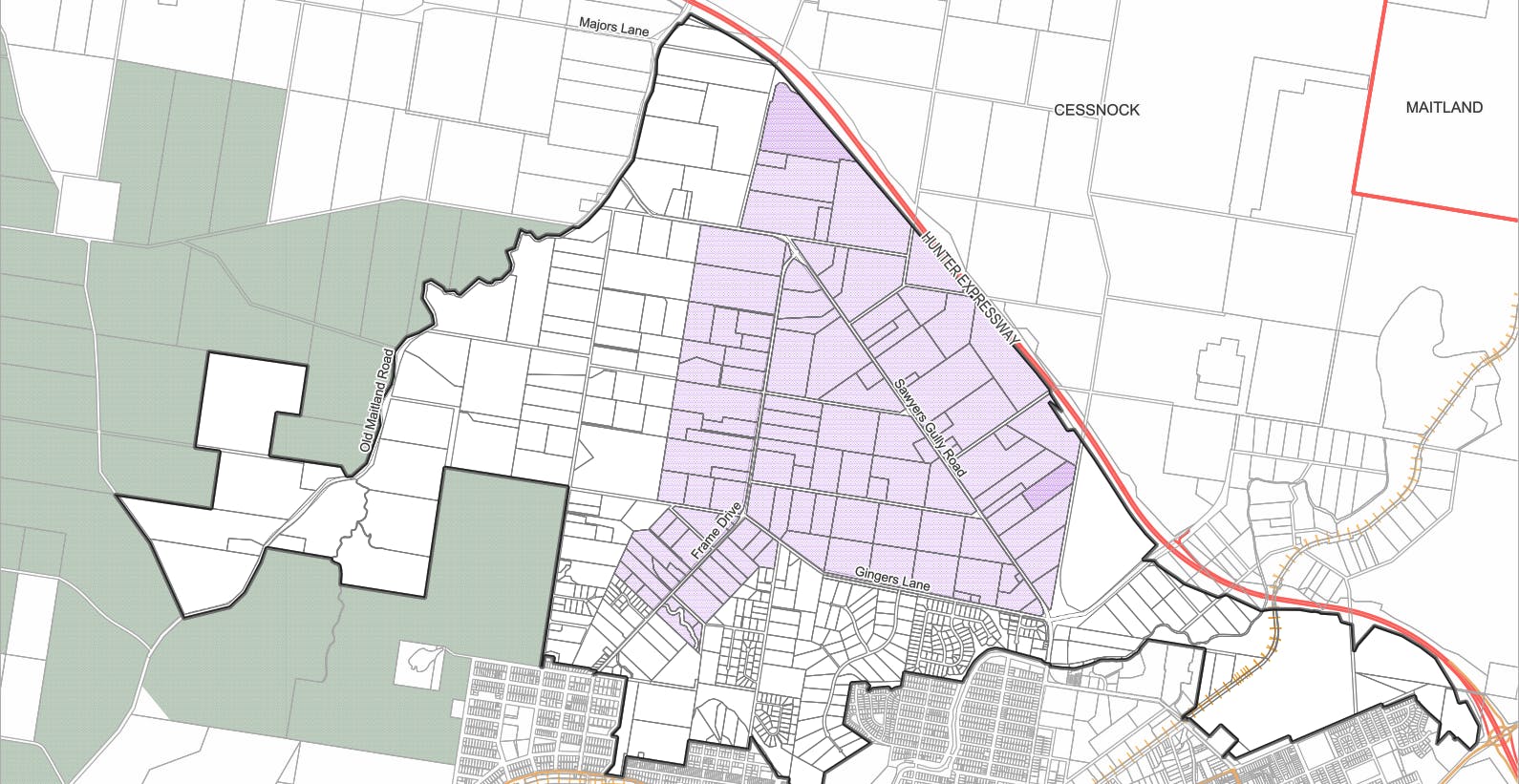
Council's initial investigations took a landscape-scale view to understand regional environmental functions, habitat connectivity, and catchment-wide flood risks. Click here to see aerial map of the entire SGUIA area.
Based on this broad analysis, Council is now concentrating on a Focused Investigation Area for further study. Click here to see the ‘Focused Investigation Area’
Structure Planning is a long-term exercise that serves to coordinate issues like biodiversity, transport, and flooding from the outset. The Structure Plan will identify the most sustainable locations for future residential growth and potentially a new local centre, and establish the 'ground rules' for future rezonings.
Once the Structure Plan is adopted, it serves as a framework for the future. Council will not be rezoning the land; instead, individual landowners or developers may choose to lodge Planning Proposals (rezoning applications) for their specific sites. To be successful, these proposals must demonstrate consistency with the Structure Plan’s requirements - particularly regarding environmental avoidance and the delivery of essential infrastructure like water, sewer, and roads.
We are committed to working closely with the Sawyers Gully community. We will provide regular updates here as new data becomes available, and we invite you to contact the planning team at any time to discuss the project.
Project Update - July 2026 Draft Flood Study on Public Exhibition
Council is now seeking feedback on the SGUIA Draft Flood Study, which is a key technical input to the Structure Plan. The draft Flood Study covers areas around Abermain, Sawyers Gully, Loxford and Weston, with a focus on overland flow from catchments surrounding Deep Creek, Bishop Creek and Black Waterholes Creek. Detailed flood modelling by specialist consultants WMAwater Pty Ltd, based on rainfall, topography, waterways, land‑use and historic flood information, provides Council with a clearer understanding of how flooding behaves across the catchment.
This project supports safer, more resilient planning, informs emergency management and improves community understanding of flood risk.
The Draft Flood Study is on public exhibition from 13 July to 10 August 2026. A community information session will be held at Abermain Plaza Hall, 3 Bathurst Street, Abermain, on Monday 27 July from 4:00–6:00 PM.
For more information and to have your say, please visit the Draft Flood Study engagement page on Together Cessnock.
Project Update - March 2026 (High Environmental Values Study Completion)
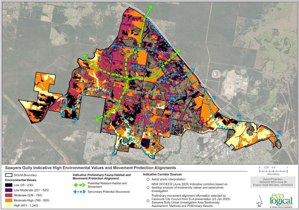
Council is pleased to announce the completion of the High Environmental Value (HEV) Assessment, prepared by EcoLogical (see December 2024 update). This study is a foundational piece of evidence that helps Council understand the unique landscape-scale environmental assets within the Sawyers Gully investigation area.
Click here to access the Final HEV Assessment Report
What does this study tell us?
The HEV assessment indicates areas within the study area that are more likely to have significant biodiversity values. By understanding these values early, Council can apply the principle of Strategic Avoidance. This study provides the foundational evidence for the ‘genuine measures’ test required under NSW biodiversity legislation, directing future growth away from high value environmental areas and protecting regional habitat connectivity.
Initial findings suggest that the central and eastern portions of the investigation area generally contain fewer landscape-scale environmental constraints than the western and northern fringes. By focusing here, we ensure that vital corridors (such as the link between Werakata National Park and Loxford) remain intact and functional at a landscape scale.
Next Steps: Framework and Investigatory Studies
Council’s Flood Study (see April 2025 update) will be publicly exhibited. Along with the HEV assessment, the conclusion of the Flood Study completes our update of the major baseline studies required to understand landscape-scale risks.
From there, Council will begin working on more detailed structure planning initiatives, including technical studies for issues such as (but not limited to) land use conflict risks, emergency planning and response, social impacts and community needs, and growth infrastructure. Council will also be developing frameworks and processes to ensure future approvals are informed by place-based and cultural values.
What is the "Focused Investigation Area"?
To ensure Council’s resources are used efficiently, we will move into a ‘Focused Investigation Area’ for the next set of investigatory studies. The Focused Investigation Area represents land where the cumulative impact of development is expected to be lowest. Moving forward, technical studies will prioritise this area to ensure growth is place-based and consistent with the landscape-scale avoidance already identified.
Click here to see the ‘Focused Investigation Area’
Please note: Being included in this Focused Investigation Area does not guarantee that land is suitable for development. It simply means these areas will be the subject of more detailed investigations to determine their actual capacity for growth.
A Reminder: This is a Blueprint, Not a Rezoning
The Structure Plan will not change the zoning of your land. It is a high-level "blueprint" designed to coordinate infrastructure and protect environmental values across the whole region. Landowners remain in the driver’s seat: you decide if and when you wish to pursue development or participate in future Planning Proposals once the Structure Plan is finalised. Any future Planning Proposals will need to demonstrate consistency with the strategic avoidance framework established by this study.
Project Update - April 2025 (Flood Study Update)
Cessnock City Council has engaged WMAwater Pty Ltd to undertake the flood study for the Sawyers Gully Urban Investigation Area (SGUIA).
The Flood Study is currently in its inception stage where the consultants are collecting and collating data on flooding and the catchment. This data will be used for development of computational flood models. These computer models will provide the technical information on flooding that will be used by Council to understand flood risks and manage development in the floodplain.
The participation of the community is essential to the success of the study, particularly when it comes to locality specific flood information. Council welcomes your feedback.
Survey submissions closed on 30 May 2025. Thank you for your feedback.
Interactive Map submissions closed on 30 May 2025. Thank you for your submissions.
Project Update - January 2025
Council has been successful in securing funding under the 2024 Floodplain Management Program managed by the Department of Climate Change, Energy, the Environment and Water (DCCEEW). This funding will be utilised to undertake a local catchment flood study for the SGUIA. A consultant to undertake this work is expected to be appointed in late January.
Project Update - December 2024
As part of the ongoing preparation for the Sawyers Gully Urban Investigation Area (SGUIA) structure plan, consultants will be conducting fieldwork investigations in and around the area starting 9 December 2024. These investigations form part of the biodiversity assessment and are a critical step in understanding the environmental characteristics of the area.
The fieldwork will primarily occur from road reserves. If access to individual properties is required, this is expected to take place early in 2025. Affected landowners will receive written advice from Council in advance.
What does the assessment aim to achieve?
This particular assessment is a high-level assessment. The aim of the work is to understand High Environmental Value (HEV) assets within the study area.
HEV comprises a range of factors including but not limited to:
- Areas of sensitive biodiversity
- Native vegetation of high conservation value
- Threatened species (including key habitat)
The fieldwork being undertaken is primarily to confirm the accuracy of available data, as well as establish the condition and suitability of habitat for particular types of native fauna.
The study will also seek to identify functional biodiversity corridors and connections of local and regional importance within and beyond the SGUIA.
We thank you for your understanding and cooperation as this important work progresses. Updates will continue to be provided on this page and via the project newsletter which you can sign up for by clicking the button at the top right of this page.
Please reach out to our team via the information provided in the "Who's Listening" section on the right of this page if you have any questions or concerns.
Project Update - October 2024
Council has engaged EcoLogical Australia Pty Ltd (EcoLogical) to undertake the first of a number of investigations for the SGUIA.
EcoLogical are an environmental and heritage consultancy who will be undertaking a biodiversity assessment of the SGUIA. The work will primarily be desktop based, however some field work may be required. Most will be undertaken on/from publicly available land, but some individual property access may be required. Council will be in contact with individual land owners if this is proposed.
The assessment is expected to be completed in early 2025.
Once the findings of the above are available, Council will be in a better position to determine which areas of the SGUIA may be suitable for development. These areas will be further analysed by a further range of studies (e.g. contamination, heritage, acoustics, odour etc.) to inform the preparation of a draft Structure Plan for the area.
Timeline
Late 2024 – Mid 2025: Primary Constraints Analysis (biodiversity, flooding)
2025: Secondary Constraints Analysis (Contamination, heritage, acoustics, odour etc.)
2025: Draft Structure Plan and Agency consultation
2025/2026: Servicing Investigations (traffic & transport, social infrastructure etc.)
2026: Draft structure plan public exhibition and finalisation
The timeframes provided are indicative only and are subject to a number of factors, including the resolution of primary constraints (such as biodiversity and flooding), as well as the engagement of consultants and the timely delivery of their reports and recommendations.
The investigation is a long-term project and it will take several years. Once the Structure Plan is finalised, areas in the SGUIA will be rezoned and developed in stages based mainly on the delivery of infrastructure.
Throughout the project there will be formal opportunities to participate in the planning of the SGUIA and this page will updated with new information and timelines throughout the project.
Structure Plan Presentation
Click here to see a Presentation of the Structure Plan for the project.
This presentation includes:
- Project timeline
- Key findings
- Project approach and deliverables
- And the project's next steps.
Book a phone, or online meeting with the planning team
If you have any questions or concerns that you would like to talk over with the Strategic Planning team, please leave your details to organise a time with the Planning team to talk about the Sawyers Gully Urban Investigation Area over the phone or via Zoom/Microsoft Teams.
Nominate your preferred time for us to contact you, and the team will confirm or get in touch to work out an alternative.
Click here to make a Phone/online booking.
Frequently asked questions
You can see a list of questions asked around this project by clicking this link.
Ask a question to the Planning Team
Have a quick question? Get a direct response from the planning team by clicking here.